Clay Hamlin MarshPosted on August 20, 2021 |
Image

|
HISTORY MYSTERY: Clay Hamlin Marsh
On October 8, 1992, the Herald American stated, “The Stanley Hamlin Game Management Area (GMA), formerly the Clay Marsh, may soon become the conservation education facility and duck-producing area its namesake worked a lifetime to promote.” Ward Dukelow, a DEC senior wildlife biologist and waterfowl specialist overseeing the project said, “This marsh is not a stinking, mosquito-infested swamp people think it is.”
He also tells us that the Hamlin Marsh was once a highly successful muck farming region. It became a wetland when the state constructed the lock in Fulton and the canal rose three feet pushing flood waters up Mud Creek which meandered unobstructed through the muck land onion fields. Mud Creek originates in Cicero Swamp. Eventually, the vegetation swallowed up the drainage ditches and Mud Creek. The water holes utilized by waterfowl became choked with weeds and cattails.
With approval from the public after hearings at Clay Town Hall and the S. S. Army Corps of Engineers, approximately 53, 173 cubic yards of vegetation and some soil was dredged from the existing canals which snake through the 4-mile long by 1-mile wide swamp in the southern portion of the town of Clay. Feeder canals were dredged to connect two Parking areas off Henry Clay Boulevard and one each on Davis road and bear Road.
The dredged material was used to construct 127 waterfowl nesting areas, some in isolation and others along the canoe trail which is approximately 5.4 miles long. Before the dredging, the marsh was filled mostly with cattails and other vegetation and had slowly lost its attractiveness to wildlife. The cost was paid with Conservation Fund money from the sale of voluntary state Duck Stamps and prints. This was matched with Ducks Unlimited MARSH money.
The Hamlin GMA had been renamed after Stanley Hamlin, former owner (the state had begun purchasing the marsh from the Hamlin’s in 1975.) and lifelong conservationist had been killed in an automobile accident a few months prior to the onset of this project. Before his death, Hamlin had charted the irrigation ditches and creek’s path from memory. He had been active in waterfowl conservation for over 50 years. This saved the project thousands of dollars. The DEC knew exactly where to dredge so as not to interrupt the existing wildlife cycle and made it easier to make the canoe channels.
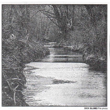
This photo taken in 1997 shows a section of the marsh after it was dredged to allow better access to visitors. The Hamlin Marsh is home to at least 200 species of birds. The walking trail which, is about 2.5 miles long, loops through the southwest end of the marsh. It leads to the edge of Mud Creek, a body of water that still meanders through the marsh. At water’s edge, 5 miles of open marsh invites canoeists, hunters, anglers and bird watchers to explore the 1,473 acre area. Dogs are allowed on the walking trail as long as their owners keep them on leashes and clean up after them. Motorized vehicles are not allowed on the trail and mountain bikes are discouraged.
From the 1997 article, autumn is the best time to visit the Hamlin Marsh. The scenery is gorgeous and the birds are everywhere – nesting or stopping on their way south people are still canoeing. Many are bird watching or painting pictures. Many are hiking or just enjoying nature.
Dorothy Heller, Historian
8-20-21
Other
History Mysteries

Ethel Champion - The Pride of Clay
History Mystery | Jun 10, 2021
HISTORY MYSTERY: Ethel Champion - The Pride of Clay


